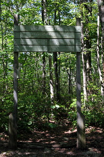
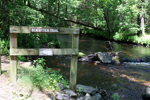
Showing posts with label woods. Show all posts

Sunday, May 12, 2013

Bear Mt & Mt.Frissell, CT

Riga Junction
It has been an embarrassingly long time since I've posted, and I will be trying to get some long-overdue trip reports written up...here's one from last summer!

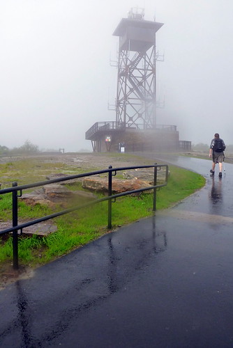
Our continued pursuit of state high points led us next to...Connecticut! CT is one of only two states (I believe Nevada is the other one) to have a high point located not at the geographical summit of a mountain, but on a slope of a mountain that summits in an adjacent state. The south slope of Mt. Frissell (which tops out in Massachusetts) claims the state's high point at 2,380 ft, and is marked rather unassumingly by a teensy little green-painted brass pole just a few inches high, which has been dubbed by the affectionate moniker of CT's "Green Stake". 

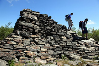
Pyramid at summit of Bear Mountain
While planning our hike, I figured we would throw in CT's highest summit for good measure - the more popular Bear Mountain (2,316 ft). I planned our hike based on this trail description, which claimed that it would take us 6 hours and approximately 9.6 miles (we later discovered that 9.6 miles may have been a little misleading!) to bag both peaks.

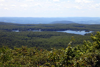
A sunny July weekend found us hiking up our packs at the Undermountain Trailhead off Rt.41 in Salisbury, CT. The initial climb from the Undermountain lot to Riga Junction where we turned north on the Appalachian Trail was a breeze, and about an hour after we hit the trail, we found ourselves clambering up the pyramid of boulders that marked the summit of Bear Mountain. The view from the top revealed rolling green hills dotted with lakes - a pleasant sight to enjoy as we munched on home-baked banana bread to fortify ourselves for the next leg of the hike. We scoffed a little as we read the informative plaque that marked the "highest ground in Connecticut" - we knew better, of course!  

View from Bear Mountain's summit
I was a little uncertain about how the trails connected over to Mt. Frissell past this point, but we chatted with a few fellow hikers who had done the loop before and they offered to show us the turn-off at the base of Bear's north side. However, they seemed surprised when I mentioned that it was supposed to be 9.6 miles for the round trip, as they seemed to remember it being closer to 12-13 miles - a warning I should have taken more seriously, I suppose!

We clambered down Bear's significantly steeper north slope together (doing fairly well at making conversation simultaneously, I must say - they were excited to meet someone from Malaysia as they had either spent significant time there or had friends from there, or something of the sort - I can't remember!), and once the trail had leveled off a bit we parted ways (with a selamat jalan!) as our unblazed/unsigned (but wide) trail came up on the left.    

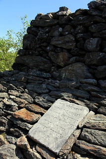
Misleading plaque on Bear Mt
We followed the flat trail over a mossy and slightly swampy area, past the AMC northwest cabin and on to its intersection with Mt.Washington road. It took us a minute or two to pick up the trail across the road since there was no signage to be seen, but we started following some red blazes and soon came across another hiker coming the other way who confirmed that we were heading up the right trail. 

I suppose I must say that we were guilty of assuming that CT wouldn't stack up to the 4000-footers of NH and NY, and that our (supposedly) 10-mile day would be a breeze (especially after how easy Bear had been), but as we hit our first scramble, I finally figured out that CT did have some good uphill inclines to offer. We huffed and puffed our way up and over the summit of Round Mountain (it had seemed like such a minor detail in my trail description!), swore a little at how we were nowhere near to being done, and huffed and puffed our way up another very respectably steep portion of trail to the top of Frissell. I believe there is supposed to be a log somewhere at the summit, but we didn't find it or sign it. 

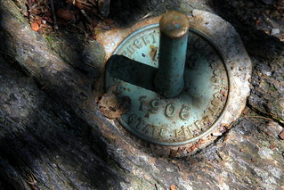
The Green Stake in all its glory
We kept going along on the trail in search of the Green Stake, and not too long after we started going downhill we came across an older couple having a snack and enjoying the view. We stopped to ask them about the stake and would you know, they were sitting right next to it! We would probably have walked right by it if they hadn't been there - yes, it's actually that tiny (that's what she said?).

View from the high point
High point photos and a breather later, we decided to keep trucking onwards to see if we could find the tri-state marker where CT, NY and MA all come together. We weren't sure how far we needed to go, but after clambering down a steep section (that I lamented we would have to climb back up later), we came across the stone pillar (I'm estimating about 1/3 miles from the high point...you can't miss it). As many have pointed out, NY and MA have their state names well-engraved into the pillar, while CT has needed all the help that it could get from hikers with rudimentary etching skills and a sharp stick or stone.
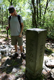
Tri State Marker
We took more obligatory photos (while I made nerdy references to existing in 3 states simultaneously, not that I know much about triple points or physics in general) and made the walk around the marker to make sure we had actually set foot in all 3 states before turning around to embark on our return journey. At this point the summer heat was getting to me, and I was definitely somewhat exhausted and headachey on the trek back to the car - also, we were definitely agreeing with the 13-mile estimate at this point and had to embrace the fact that we were getting a little bit of a longer workout than anticipated.

Snake slough!
We did come across a cool snake slough (rare rattlesnakes are supposed to inhabit this area, although we didn't see any) on our way back up and across Frissell and Round Mountain (this stretch seemed to go on forever), and once we had crossed the dirt road and made it back to where we had turned off after Bear Mt, we kept left to loop around on Paradise Lane Trail so as not to summit Bear again. At this point,  the trail back was pretty easy and we did make it back to our car about 6 hours and change after we left. 

All in all, definitely a good day's hike that left me with legs more achy than I had anticipated...but another high point bagged is always a great feeling! I didn't take too many photos on this hike but there are a few more over on my flickr site.

Tuesday, December 4, 2012

Wachusett Hike - An "Eft-ing" Good Time!

Windmill just off Harrington
Living in Rhode Island means that the immediate vicinity tends to be rather flat. For someone who likes hauling herself up things that reach a little higher, this tends to mean a drive of at least 2.5 hours each way - not always the most appealing thing to do for a day hike. Since driving is one of the few things in life that makes me nervous, the boyfriend always does the brunt of the driving. It makes me ever-so-slightly guilty, but never quite feel guilty enough to volunteer to drive, but I figured I could at least find something a little nearer to us - and thus the hunt for a littler mountain closer to home began.

I was hoping to find something that would still provide a decent hike sans the long drive, and finally settled on Mt. Wachusett in MA - high point of Worcester county and the 92-mile long Midstate Trail, topping out at 2006 feet. While the peak seemed to be more famous for its skiing than anything else, I figured it would still provide enough mileage on the trails that circle the park to make up for lack of elevation gain. I styled a 7.5 mile fancy twisted figure-eight loop based on this trail description, which sounded like a good way to cover most of the trails in the reservation and give us a good feeling for the area.

Red eft
A mid-August morning brought grey skies and a 30% chance of "light rain" on the forecast, which we figured was worth the gamble - plus, the trail description had mentioned a sighting of a red eft in rainy conditions, and newts seemed like a worthwhile cause to brave the potential wet weather, especially since none of us had seen them before. The weather seemed promising as we drove northwards, with only a few sprinkles gracing the journey, but by the time we pulled up at the trailhead the clouds had swept in and rain had started coming down fairly steadily. Still in good spirits and figuring that I had to field test my Outdoor Research Reflexa jacket sooner or later, we hit Harrington trail and began our ascent.

Our first stop was a little side trail to the windmill farm, where we peered through rain-clogged eyelashes at the white towers. Our observation of the windmills was sadly short-lived, as we quickly realized that the mosquitoes were not being dampened by the weather whatsoever, and we bid a hasty retreat while slapping, scratching and belatedly trying to spray ourselves down with repellent - a somewhat pathetic endeavor, as the rain had gained even more enthusiasm and was washing away the spray as quickly as we could attempt to get it on.

Waterfall of a trail
We headed back on Harrington and observed that the "30% chance of light rain" was now decidedly in the "100% steady and heavy" category, and the trail was starting to resemble more of a waterfall than a trail. Onwards we trudged through the muddy rushing water, feet sloshing around in waterproof boots that were now doing more to keep water in rather than keep them out, and myself rapidly coming to the unfortunate and uncomfortable realization that a mosquito had somehow managed to give me a loving bite right on my (now fat and swollen) lip. The rain, instead of dissuading the insects as we had hoped, only seemed to give them reason to become trapped in our hoods - I suppose the appeal of a dry warm nook and the proximity of tasty human blood made for an irresistible combination - and to our dismay, the high-pitched whining of wings and a frenzied shaking of our heads soon became an annoying constant as we ventured on uphill.

Fire tower at summit
As we were wondering why we thought it would be a good idea to squelch miserably through the woods rather than stay cozy and dry inside, we spotted a bright orange streak that stood out in stark contrast to the soggy moss it was framed against. Closer inspection revealed our first red eft of the day! We oohed and ahhed at the little lizard and admired his neon black-ringed spots, delighted at his awkward waddling gait, and pondered his zen-like indifference towards both us and the weather. It took us a little while to tear ourselves away from our tiny orange friend, but when we started moving again, we started seeing more orange lizards literally everywhere - smack in the middle of the trail, sitting on rocks or hanging out on tree trunks. To our delight, the woods were replete with efts that had emerged to enjoy the downpour that Mother Nature was unleashing upon us. We resorted to walking gingerly at this point to avoid squishing any of the little critters, and even moved some that were sitting in the middle of trail so they wouldn't be stepped on by any other crazy hikers who might have been out that day.

A regal toad on the trail
Tallying efts proved to be the only distraction from the incessant cold rain and the horrible feeling of squishy sodden socks as we squelched our way to the top. We finally reached the summit, a drenched and disheveled trio (2 of our party even managed to aid and abet the rain by dumping accumulated rainwater from their hoods down their backs), and took a minute to huddle beneath a little overhang at the fire tower and attempted to wring our muddy socks out, although to not much avail. We were halfway through our planned loop at this point, but when I broached the suggestion of continuing our hike down to Balance Rock on the other side of the mountain, I was greeted with a hearty nay - and I must admit I was pretty relieved that my proposal was shut down.


Another eft hanging out
It seemed as if the desire for dry feet had won out over any further inklings for adventure that day. With not much of a view to enjoy at the summit beyond snapping a quick soggy self-portrait, there seemed to be no reason to linger, and so we headed back down Mountain House Trail - Bicentennial Trail - Echo Lake Trail, spotting some more amphibious friends on the way - yet more efts, a toad and some frogs, who were obviously faring better in the rain than we were. We made it back to the car around 3 hours after we embarked (thanks to a lot of dilly-dallying and looking for efts), with a grand tally of a whopping 44 live efts spotted that day and many scooped up and off the road to safety, although sadly we did also see many a mangled remain of an unfortunate lizard who had met one car too many.

Echo Lake Reflection
We clambered into the shelter of the car, although of course the rain had died down by this point. Still, it was a relief to strip off wet socks and free wrinkled toes from their watery confines, and we enviously watched another hiking couple parked just down the road from us who had had the foresight to bring extra clothing to change into post-hike. I peeled off my new rain jacket to discover that it had soaked through pretty much everywhere - it was decidedly a trip back to REI for this jacket, which was kind of disappointing (it was such a pretty berry color!), because it had seemed to fit well and had plenty of nifty features...but what use is the fanciest rain jacket if it doesn't keep you dry?

We were more than ready for warm beverages and a hot shower at this point, and were excited to get on our way home, although I had a feeling we would return to Wachusett at some point - if for nothing else, to see what kind of view was to actually be had from the top.

Thursday, September 13, 2012

Stepstone Falls, RI

Sign at the trailhead
Rhode Island's vaunted position as the smallest state in the US left us with a little skepticism as to what its highest waterfall, Stepstone Falls in Exeter, could offer, but we decided to finally give it a chance on a lovely spring afternoon. After all, even a small state could dream big and be gutsy - RI does have claim to the longest state name, and was also the first of the original 13 colonies to declare independence from Britain!

Spiderwort
Some internet research dragged up this trail description/guide, which we stuck to for the most part, although actual trail maps of Arcadia management area proved dismally difficult to procure - this shabbily-drawn map was the best that I could find. Having already picked the wrong trail once on our first attempt at finding the falls, I was determined to actually succeed in reaching them this time around. The falls, as we found out, can actually be accessed by car, but where's the fun in that?

We took Escoheag Hill Road to the unpaved Austin Farm Road (the turnoff is unmarked and a little confusing, as it looks like someone's driveway) and parked at the start of the Ben Utter Trail, just before Falls River. Ben Utter winds its picturesque way upstream, hugging the river for about 1.7 easy and flat miles before reaching the cascades.

The woods were awash in golden spring sunlight, the air jewel-bright with dancing iridescent dragonflies, and nature's glorious details made for a pleasant walk. Distracted by the bounties of nature, we missed the old mill site, but did manage to spot some cool flora and fauna, including wildflowers like spiderwort and pink lady's slippers, some fascinatingly translucent corpse plants/ghost plants, and our first woodpecker sightings - we'd only ever heard them before, and we had a ball watching them work their way merrily at the tree branches.

Dragonfly
The falls were a pleasant surprise as they actually turned out to be bigger and more widespread than we thought they would be. We were also surprised to see a couple sitting by the cascades in camp chairs, before we spotted their car a little ways away and realized that there was a road that went up to the falls. We pottered around for a bit and checked out the falls from both sides before heading back.

Although it sure was no good slog up a 4000-footer (my personal preference in the North East), Stepstone Falls turned out to be a pleasant half day excursion, and a leisurely stroll in the woods, although I would definitely recommend going after some recent rainfall. More photos can be found on my Flickr page!

Stepstone Falls
Stepstone Falls